This program displays digital images and GPS Tags
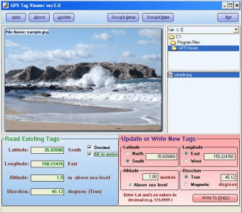
GPS Tag Viewer allows you to browse images in a folder. It previews the images and displays GPS information if available. The coordinates can be sent to Google Maps for preview.
The displayed tags are:
- GPSLatitude
- GPSLongitude
- GPSLatitudeRef
- GPSLongitudeRef
- GPSAltitude
- GPSAltitudeRef
- GPSDirection
It is possible to change Longitude and Latitude displayed format from traditional (degrees and minutes) to decimal. Other options include opening the GPS location in Google Maps (internet connection required). Users can select different initial Google Map settings like zoom and display type (map, satellite, hybrid, terrain).
The program supports drag&dropping files into the display area or opening them by clicking on file names in the File Box.
This program is capable of reading most JPEG, JPEG2000, TIFF and RAW files.

It is a program to view on 3D digital elevation maps mixed with data acquired


Comments